Εμφάνιση αναρτήσεων με ετικέτα Documents. Εμφάνιση όλων των αναρτήσεων

21 Μαΐου, 2024

Macedonia during the Spread of Christianity (down to 180 A.D.)


Map depicting the Spread of Christianity down to 180 A.D. by Adolf Harnack


Detail from the map


Macedonia lies where is currently the Greek Province of Macedonia. 

On the other hand the map shows clearly Skopje out of Macedonia, while being a part of Moesia Superior.


11 Μαρτίου, 2024

Γάμος στην Μακεδονία


Αυτό το παλαιό ντοκιμαντέρ παρουσιάζει την αναπαράσταση Ελληνικού γάμου στην περιοχή της Μακεδονίας.

Η αναπαράσταση γίνεται στο χωριό Δρυμό με τότε πληθυσμό 2500 κατοίκων, όλοι ντόπιοι Μακεδόνες.

Πολλά από τα τραγούδια, οι χοροί και τα έθιμα έχουν τις ρίζες τους στην προ χριστιανική αρχαία Ελλάδα και ο θεατής έχει την ευκαιρία να παρακολουθήσει και να ακούσει την επεξήγηση και τους συμβολισμούς κάθε πράξης της τελετουργίας.

This old documentary shows a reconstruction of a traditional Greek wedding in the area of Macedonia.

 The reconstruction takes place in the village of Drimos with a population of 2500 residents, all local Macedonians.

Many of the songs, dances and customs presented in the documentary have their origins to the pre Christian ancient Greece and the viewer has the opportunity to observe and listen to the explanation and the symbolism of every action during the ritual. 


01 Νοεμβρίου, 2023

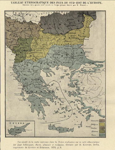
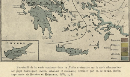
Macedonia:Ethnographic map of Heinrich Kiepert (1878)


Rare ethnographic map  by the  German cartographer,Heinrich Kiepert depicting Balkans


(a) The ethnographic maps of the  famous cartographer who was distinguished for the scientific value of his maps,  depicts the region of Macedonia. as being inhabited primarily by Greeks and secondly by Bulgarians.  

(b) neither Kiepert in his time knew any fictitious “Macedonian” nationality. On the contrary the Slavs of his time were Bulgarians and Serbs.

Geographer Heinrich Kiepert (1818-1899) is generally reckoned one of the more important scholarly cartographers of the second half of the 19th century. The fame attached to the name of this renowned German geographer and cartographer, H dates from the appearance of his distinguished Atlas von Hellas (1846).


Kiepert acquired one of his interests-the historical geography of the classical world-in his student days at the University of Berlin, where he worked with Carl Ritter (1779-1859). Ritter and Kiepert produced what appears to have been one of the first modern atlases of the ancient Greek world, Topographisch-historischer Atlas von Hellas und den hellenischen Colonien in 24 Blättern (1840-1846). Several additional compilations of maps of the classical world followed: Bibel-Atlas (1847); Historisch-geographischer Atlas der alten Welt (1848); Atlas antiquus (1854); Formae orbis antiqui (1893); and Formae urbis Romae antiquae (1896). Many of these works were reissued in numerous editions, including translations.

Another major interest was the Ottoman Empire, where Kiepert travelled numerous times, gathering enough data to produce several major maps of the Ottoman world between the 1840s and 1890s.


More Infos about Heinrich Kiepert’s life are found in the University of Chicago Library  (The Maps of Heinrich Kiepert )


22 Μαρτίου, 2023

Μανόλης Ανδρόνικος - 23 Οκτωβρίου 1919


 Συνέντευξη στο Κεντρικό Αμφιθέατρο της Φιλοσοφικής,24/11/1977

Επιφανής αρχαιολόγος με πλούσιο ανασκαφικό έργο, ο Μανόλης Ανδρόνικος γεννήθηκε στις 23 Οκτωβρίου 1919 στην Προύσα της Μ.Ασίας. Τακτικός Καθηγητής στο Αριστοτέλειο Πανεπιστήμιο Θεσσαλονίκης, ο Μ.Ανδρόνικος έγινε γνωστός όταν τον Νοέμβριο του 1977 φέρνει στο φως στη Βεργίνα τον πρώτο ασύλητο μακεδονικό τάφο, γεγονός που αποτέλεσε μια από τις σημαντικότερες αρχαιολογικές ανακαλύψεις του 20ου αιώνα.

Το Αρχείο της ΕΡΤ τιμώντας την επέτειο των 100 ετών από τη γέννηση του σπουδαίου Έλληνα αρχαιολόγου παρουσιάζει μια σειρά ανέκδοτων φωτογραφικών τεκμηρίων με θέμα την ανακάλυψη των βασιλικών τάφων στη Βεργίνα. Οι φωτογραφίες προέρχονται από τη Συλλογή του φωτορεπόρτερ του Associated Press Αριστοτέλη Σαρρηκώστα. Παρουσιάζονται στιγμιότυπα από τη συνέντευξη τύπου που έδωσε ο Μανόλης Ανδρόνικος στις 24 Νοεμβρίου 1977 στην  Φιλοσοφική Σχολή του Αριστοτελείου Πανεπιστημίου Θεσσαλονίκης-παρουσία εκπροσώπων της Κυβέρνησης, της επιστημονικής κοινότητας και πλήθους δημοσιογράφων  στην οποία ανακοίνωσε επισήμως την ανακάλυψη του τάφου του Φιλίππου Β’, φωτογραφίες από τον χώρο της ανασκαφής στη Βεργίνα, καθώς και οι πρώτες φωτογραφικές καταγραφές των ευρημάτων. 


Η χρυσή λάρνακα που βρέθηκε μέσα στον τάφο του Φιλίππου

Ευρήματα στο εσωτερικό του τάφου

Σχεδιάγραμμα της ανασκαφής και των ευρημάτων

Αποκαλύπτοντας την πρόσοψη του βασιλικού τάφου στη Βεργίνα

Προετοιμάζοντας τη μεταφορά των ευρημάτων της ανασκαφής. Διακρίνεται η συνεργάτιδα του Μ.Ανδρόνικου Στέλλα Δρούγου

Μεταφορά των ευρημάτων της ανασκαφής

Άποψη της ανασκαφής στη Βεργίνα

Το αστέρι με τις δεκαέξι ακτίνες στο κάλυμμα της λάρνακας

Συνέντευξη τύπου του Μ.Ανδρόνικου στο Αριστοτέλειο Πανεπιστήμιο,24/11/1977


Συνέντευξη τύπου στο Αριστοτέλειο Πανεπιστήμιο, 24/11/1977. Διακρίνεται μαζί με τον Μ.Ανδρόνικο ο Υπουργός Πολιτισμού και Επιστημών Κων/νος Τρυπάνης

Ο τάφος του Φιλίππου Β΄ υπό ανασκαφή


👉 Του Φιλίππου είναι ο τάφος που βρέθηκε στη Βεργίνα

Hans-Georg Gadamer erzählt die Geschichte der Philosophie

      Wie es anfing - Thales, Heraklit, Platon, Aristoteles     Hellenismus und Weltbürgertum - Epikur, die Stoa und Plotin         Moral u...